
Mars Global Surveyor (MGS), on September 12, 1998, returned the above image of the north polar region of Mars, as viewed from 740 miles out. The picture, courtesy of Malin Space Science Systems/NASA, is a color composite of red- and blue-band MGS imagery, combined with a processed green-band that is an average of the MGS red- and blue-band values. The asymmetrical curve of the horizon is due to spacecraft motion over the span of the exposures.The swirled-ridge patterns at the pole, extending to the southwest, are layered deposits which are partially covered by the permanent ice cap.
The spacecraft's aero braking is complete and the planned orbital parameters for mapping were achieved with such accuracy that the first planned orbital trim maneuver was cancelled. Unfortunately, accuracy was deadly off for the Mars Polar Lander, which was destroyed in the Martian atmosphere as it entered too low On September 23, 1999, and now, the health of Global Surveyor takes on added significance, as it is now the only signal-relay source available for the Mars Polar Lander, which is nearing the planet and was to use Climate Orbiter as a communications relay station.
Surveyor's one-Martian-year (687 Earth days) mapping mission was begun in March 1, 1999 after Surveyor achieved a 250-mile circular orbit with a period of two hours. The spacecraft is flying in a "fixed high-gain mapping" mode and its laser altimeter measuring instrument (MOLA) was collecting data for approximately 18 hours per day until April 1 when it began continuous mapping, returning 864,000 elevation measurements daily.
- Rather than Mars having a weak, uniform magnetic field, measurements taken as the spacecraft continued to dip into the atmosphere, slowing into its parking orbit, revealed scattered magnetic-field sources which, in pockets where they exist, are stronger than expected, leading scientists to conclude that Mars' core long ago ceased the dynamics that generate dipolar planetary magnetic fields, and that the diffuse magnetic core materials the space craft is detecting lie in the crust close to the planet's surface.
- Global Surveyor has detected evidence of another massive flood, which is estimated to have been large enough to cover an area the size of the U.S. state of Utah with 300 feet of water, which was a flood from two to three times the size of that discovered by Pathfinder. The finding is confirmation that Mars was once warm, wet and favorable to the evolution of life.
- Rather than Mars having a weak, uniform magnetic field, measurements taken as the spacecraft continued to dip into the atmosphere, slowing into its parking orbit, revealed scattered magnetic-field sources which, in pockets where they exist, are stronger than expected, leading scientists to conclude that Mars' core long ago ceased the dynamics that generate dipolar planetary magnetic fields, and that the diffuse magnetic core materials the space craft is detecting lie in the crust close to the planet's surface.
- MOLA data observations reveal that the global water distribution and movement on ancient Mars was predominantly influenced by a sloping from the South Pole to North Pole, where according to scientific models of watersheds based upon the MOLA elevation map, the lower elevations in the northern hemisphere drew water from 75 percent of the martian surface. The data also clearly reveals localized areas where water may have once formed lakes or ponds, which would be likely areas to search for substrata evidence of life.
- The apparent visual difference of the poles belies the striking similarity in elevation profiles revealed by the new mapping, which, when taking knowledge of the North Pole into account, suggests that the South Pole has significant water ice along with carbon dioxide ice. Despite the poles' elevational similarity, Mars is shaped like a pear, the mountainous southern hemesphere almost two miles higher than the northern plains hemisphere, and the entire planet is marked by vastly different geologic scales than Earth, with elevation spans from a canyon 11 miles deep to a 17-mile-high mountain--the most extreme range yet discovered in the solar system. By contrast, Tibet's Namjagbarwa Canyon, the deepest river gorge in the world, is about 3.7 miles deep, while neighboring Mt. Everest is 5.5 miles high.
- These new MOS observations have allowed scientists to more accurately estimate the amount of water on the Martian surface, which is now believed to be up to 1.2 million cubic miles (3.2 to 4.7 million cubic kilometers), or about 1.5 times the amount of ice covering Greenland. If both Polar caps are composed entirely of water, the combined volumes are equivalent to a global layer 66 to 100 feet (22 to 33 meters) deep, much less than the least amount believed to have existed in an ancient Martian ocean.
- Analysis made at Malin Space Science Systems of high-resolution Surveyor images (up to ten times better than 1970's Viking photo resolutions) obtained of the boundary areas, which in Viking photos prompted scientists to believe were ancient ocean boundaries--shorelines, has resolved the question: there is no evidence of any ocean-boundary layer present, not in the areas believed to be so in Viking photos, and not anywhere on Mars where Surveyor photos have been examined for the purpose of locating such areas. This conclusion does not rule out the previous existence of oceans, and certainly does not rule out pre-existing bodies of water, because Pathfinder has uncovered areas of substantial past water flow, but not evidence of long-ago large bodies of standing water. But the search for liquid water on Mars did find possible evidence of recent or current cyclical flow in images taken by Surveyor in June 2000. The images resolve the smallest features ever recorded from Martian orbit: sport-utility-vehicle sized rocks, believed to have been moved and deposited in events that leave geological traces similar to those left by flash floods on Earth. The water supply is believed to be about 100 to 400 meters (300 to 1,300 feet) and mostly located between 30 and 70-degree latitudes.
We see features that look like gullies formed by flowing water and the deposits of soil and rocks transported by these flows. The features appear to be so young that they might be forming today. We think we are seeing evidence of a groundwater supply, similar to an aquifer. These are new landforms that have never been seen before on Mars. I think one of the most interesting and significant aspects of this discovery is what it could mean if human explorers ever go to Mars. If water is available in substantial volumes in areas other than the poles, it would make it easier for human crews to access and use [for life support, fuel and energy sources].
- Dr. Michael Malin
Principal investigator for the MGS Mars Orbiter Camera, Malin Space Science SystemsWith today's discovery, we're no longer talking about a distant time of water-based geological activity]. The debate has moved to present-day Mars. The presence of liquid water on Mars has profound implications for the question of life, not only in the past, but perhaps even today. If life ever did develop there, and if it survives to the present time, then these landforms would be great places to look.
- Dr. Ed Weiler
Associate administrator for space science, NASA Headquarters.
- With the arrival of the Mars Global Surveyor, for the first time, Mars has fallen under the continuous scrutiny of a satellite outpost, the observations of which have so far revealed the planet to be a frigid, arid desert, where the predominant activities are the movement of dust and the seasonal advance and decline of the polar-cap frosts. Our explorers and colonists will have to be well sealed and filtered against the planet's on-the-move ocean of dust, which, under continuous observation by MGS, is made evident by dust storms, which show the most strength near the poles at the onset of autumn in the north and spring in the south, evidenced by region-wide movement of dunes and herds of dust devils which sweep the planet's mid-latitude surface. Global movement of dust is not unique to Mars. An estimated one billion tons of African dust from the Sahara is carried across the Atlantic every summer on the tradewinds.
Dust Devils of Amazonis Planitia
The inset highlights the dust devil indicated by the orange arrow.
The scale applies to the larger image, not the inset.

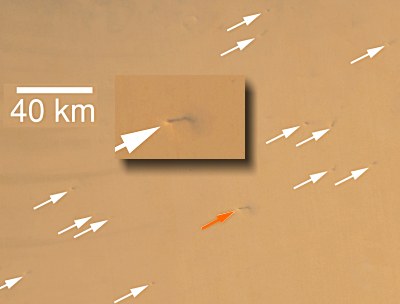
- Dust devils, first seen decades ago by Viking spacecraft, are now thought to be a major meteorological feature, responsible for much of the movement of dust, and its presence in the atmosphere in regions where they travel. They are longer lived than their Earth counterparts, usually lasting several hours in the late Martian afternoon when temperatures are highest, and almost all of Mars' dust devils dwarf their Earth counterparts in size, most being larger than Earth's tornados, with the average height about two kilometers. The largest one in the image above is picking up a column of dust around nine kilometers (more than 5-1/2 miles) high. But, although they pick up tons of dust, they are not nearly as strong as Earth's Level-1 tornadoes, because they do not have the convective, temperature-imbalanced, moisture-laden foundation of a thunderstorm system to support them.
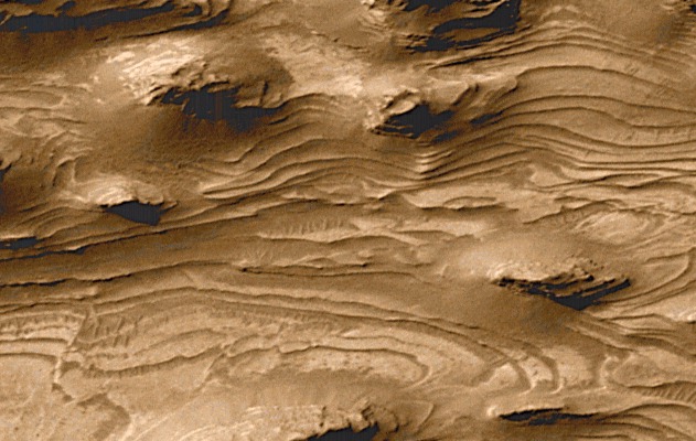
- Evidence that sedimentary rocks are widespread on Mars--layers that almost positively required water to form--has been uncovered by MGS. These layered areas are scattered about the planet's surface, and they speak to a Martian history that was far more active and Earth-like than previously believed, possibly once rife with lakes and shallow seas. Considered the most significant discovery to date, it is what biologists had been hoping to find and could be a focal point for solving some of the Red Planet's biggest mysteries.


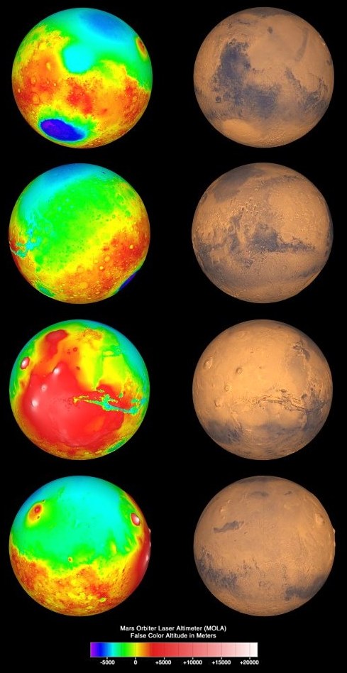
The Mars Pathfinder landing site is on the second planet image from the top. The graph at the bottom provides elevation information in meters, where the yellow represents the topographic "sea-level" datum, or the average equatorial surface height of Mars.
This is the first accurate topographic mapping of Mars, even more accurate than what is available for many regions of the Earth. The elevation accuracy is 42 feet (13 meters), and large areas of the flat northern hemisphere are known to be better than six feet (two meters).


Phobos
Viking Orbiter Photo - 1977
- Global Surveyor has also been directing its sensors, more specifically, its thermal emission spectrometer, at the closest of Mars' two moons, Phobos. Both moons, Deimos and Phobos, are believed to be captured asteroids, but Phobos holds the dual distinction of being one of the smallest moons in the solar system (27 km, largest diameter) and the closest to its parent's surface, at 6000 km (9,370 km, mean, from planet center). Its rotational and orbital periods are matched at not quite one-third of a day, and its orbit dips below the radius at which its velocity matches the rotation of the Martian surface, which condemns it to a violent end in a distant, future epoch, as it will either collide into Mars or break apart and become a ring system.
- Phobos has no atmosphere, and MGS data on its wide surface-temperature variance indicates a surface covering of dust more than several feet thick. That surface temperature ranges from 25 degrees F in the sunlight to -170 F in the shade.


